Hurricane Erin: One of the Fastest-Strengthening Storms in Atlantic History
A Storm for the Record Books

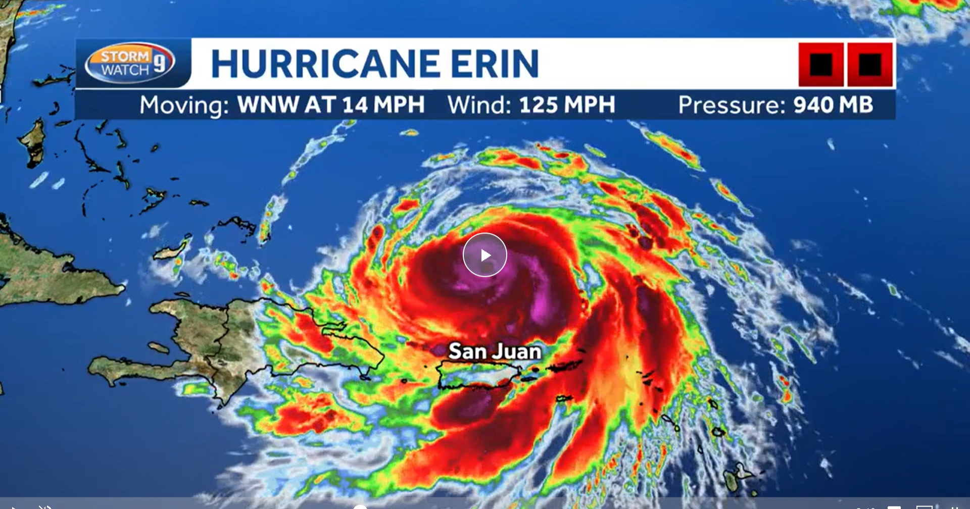
In one of the most dramatic displays of nature’s force in recent memory, Hurricane Erin (2025) has carved its name into Atlantic hurricane history. What began as a modest Category 1 hurricane with winds of 75 mph on Friday morning rapidly transformed into a Category 5 monster with near 160 mph winds by Saturday afternoon. This incredible leap in strength occurred in just over 24 hours, making Erin one of the fastest-intensifying hurricanes ever recorded in the Atlantic basin.
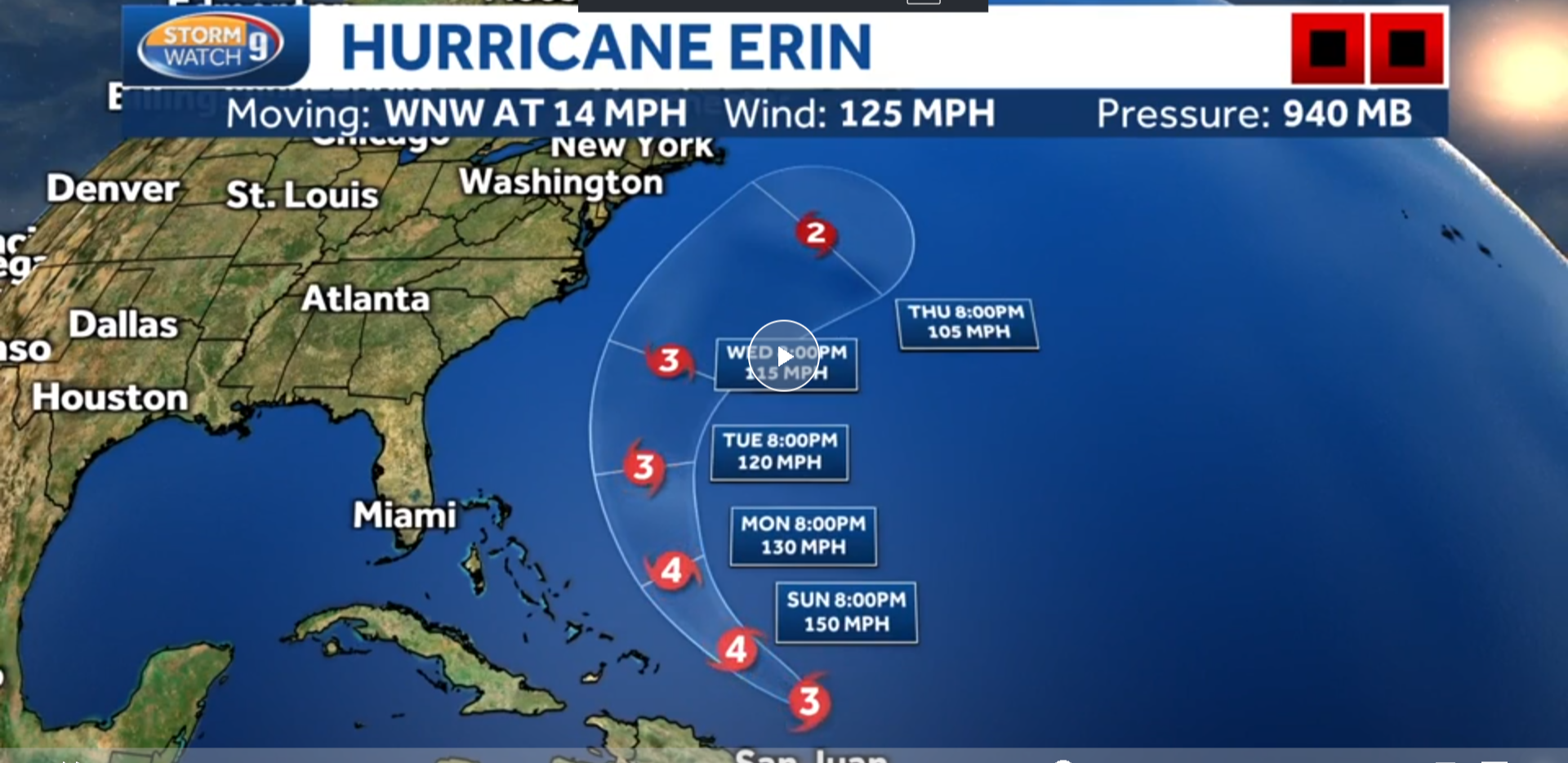
By Sunday morning, Erin weakened slightly to a Category 3 storm with 125 mph sustained winds, according to the National Hurricane Center (NHC). Despite the downgrade, the hurricane remains powerful and massive, sprawling across the western Atlantic north of the Caribbean. Forecast models suggest Erin could double or even triple in size as it tracks northward over the next several days.
Though Erin is not expected to make direct landfall on the U.S. mainland, its far-reaching effects are already being felt. From Puerto Rico to the Outer Banks, Long Island, New England, and even Atlantic Canada, dangerous rip currents, flooding rains, and hazardous surf are putting coastal communities on high alert.
Erin’s Astonishing Rapid Intensification

Meteorologists were stunned by the sheer speed of Erin’s growth. On Friday at 11 a.m., Erin was a Category 1 hurricane. By Saturday afternoon, it had exploded into a Category 5 system, strengthening by more than 80 mph in just over a day.
For reference, meteorologists define rapid intensification as a hurricane that gains at least 35 mph in wind speed within 24 hours. Erin more than doubled that benchmark.
This kind of rapid strengthening is uncommon this early in hurricane season. Historically, the most powerful storms have developed in September and October, when Atlantic waters are at their warmest. Yet Erin’s rapid growth in mid-August underscores a troubling trend: climate change is fueling earlier and stronger hurricanes.
Erin also joins an elite but concerning list of extreme storms. Since 2016, there have been 11 Category 5 hurricanes in the Atlantic, compared to just 43 ever recorded in history. Even more alarming—this is now the fourth consecutive Atlantic hurricane season to produce a Category 5 storm.
Erin’s Legacy: A Name with History
While this year’s Erin has captured global headlines, the name has been tied to destructive storms in the past.
-
1995’s Hurricane Erin struck Florida, causing major damage and contributing to 16 deaths, many from stress-related health events such as heart attacks.
-
Other storms named Erin—1989, 2001, 2007, 2013, and 2019—had varying impacts, but the repetition shows how often this storm name has surfaced in the Atlantic basin.
For many coastal residents, the name “Erin” now carries a heightened sense of dread.
Which U.S. Coastal Areas Are at Risk?

Even without a direct landfall, Erin is already impacting U.S. coastal regions and nearby islands.
-
Puerto Rico and the U.S. Virgin Islands: Torrential rain, flash flooding, and mudslides are battering the region. Over 159,000 residents in Puerto Rico lost power over the weekend.
-
Turks and Caicos Islands & Southeastern Bahamas: Under tropical storm watches as Erin’s outer bands bring rough surf and heavy rain.
-
U.S. East Coast: From North Carolina’s Outer Banks to New England, forecasters warn of 8-12 foot waves, dangerous rip currents, and beach erosion.
In Bermuda, officials are closely watching Erin’s path. A shift eastward could bring tropical-storm-force winds and dangerous surf to the island later this week.
How Many People Could Be Affected?
The scope of Erin’s potential impact is vast.
-
In Puerto Rico, over 159,000 people have already experienced power outages and flash flooding.
-
Across the Caribbean islands—Puerto Rico, the Virgin Islands, Turks and Caicos, and the Bahamas—heavy rain, flooding, and dangerous surf are ongoing.
-
Along the U.S. East Coast, millions of residents and beachgoers face risks from rip currents and high surf—even though the storm may remain far offshore.
The true number of people affected could stretch into the hundreds of thousands in the Caribbean and millions across the U.S. coastline.
Safety Measures: What Authorities and Residents Are Doing
Despite Erin’s center staying offshore, emergency officials are urging caution and taking proactive steps:
-
Storm watches and warnings are in place for Puerto Rico, the Virgin Islands, Turks and Caicos, and parts of the Bahamas.
-
In Puerto Rico, the U.S. government has deployed 200 federal staff, inspected 367 shelters, and increased emergency readiness levels.
-
Lifeguards and coastal authorities along the U.S. East Coast are warning beachgoers about rip current dangers, urging people to stay out of unguarded waters.
-
Residents are being told to monitor updates, avoid risky waters, and prepare for sudden shifts in Erin’s track.
Climate Connection: The Alarming Trend Behind Erin
Erin is not just another hurricane—it’s a glaring example of how climate change is reshaping storm patterns. Hurricanes feed off warm water, and this year the Atlantic Ocean is experiencing record-breaking surface temperatures.
These conditions act like jet fuel for storms, allowing hurricanes to grow larger and stronger in less time.
In past decades, Category 5 storms were rare. Now, they are increasingly common. Meteorologists note that rapid intensification events like Erin’s are happening more frequently and earlier in the season, leaving less time for preparation and evacuation.
As long as fossil fuel pollution continues to warm the atmosphere and oceans, experts warn that storms like Erin could become the new normal.
What Coastal Communities Should Watch For
For people living along or visiting the coast, Erin’s biggest threats will not come from direct landfall but from indirect hazards:
-
Rip Currents & High Surf: Life-threatening rip currents are expected from Florida to New England and Atlantic Canada.
-
Beach Erosion: Vulnerable coastlines, especially in the Carolinas and New Jersey, face increased risk of erosion.
-
Flooding in the Caribbean: Northern Puerto Rico and the Virgin Islands face flash flood and mudslide risks.
-
Bermuda: Depending on Erin’s final track, the island could see tropical storm impacts next week.
The National Hurricane Center continues to stress that forecast paths can change, meaning vigilance is critical.
Final Thoughts: Erin’s Warning for the Future
Hurricane Erin’s rise from Category 1 to Category 5 in just 24 hours is a wake-up call. While the storm may spare the U.S. mainland from direct landfall, its size and strength are a stark reminder of how powerful and unpredictable hurricanes are becoming in a warming world.
For millions across the Caribbean, the East Coast, and Atlantic Canada, the risks from flooding, erosion, and rip currents are very real. With the 2025 hurricane season still at its peak, Erin may not be the last record-breaking storm we see this year.
The message from experts is clear: climate-fueled rapid intensification is here to stay. Communities must prepare not just for landfalling storms but for the far-reaching ripple effects of powerful hurricanes like Erin.


